ADSB Flight Tracker Lite
- 3.8
- Rating
- 50.00K
- Installs
- Free
- Price
 Analysis by App-foxy
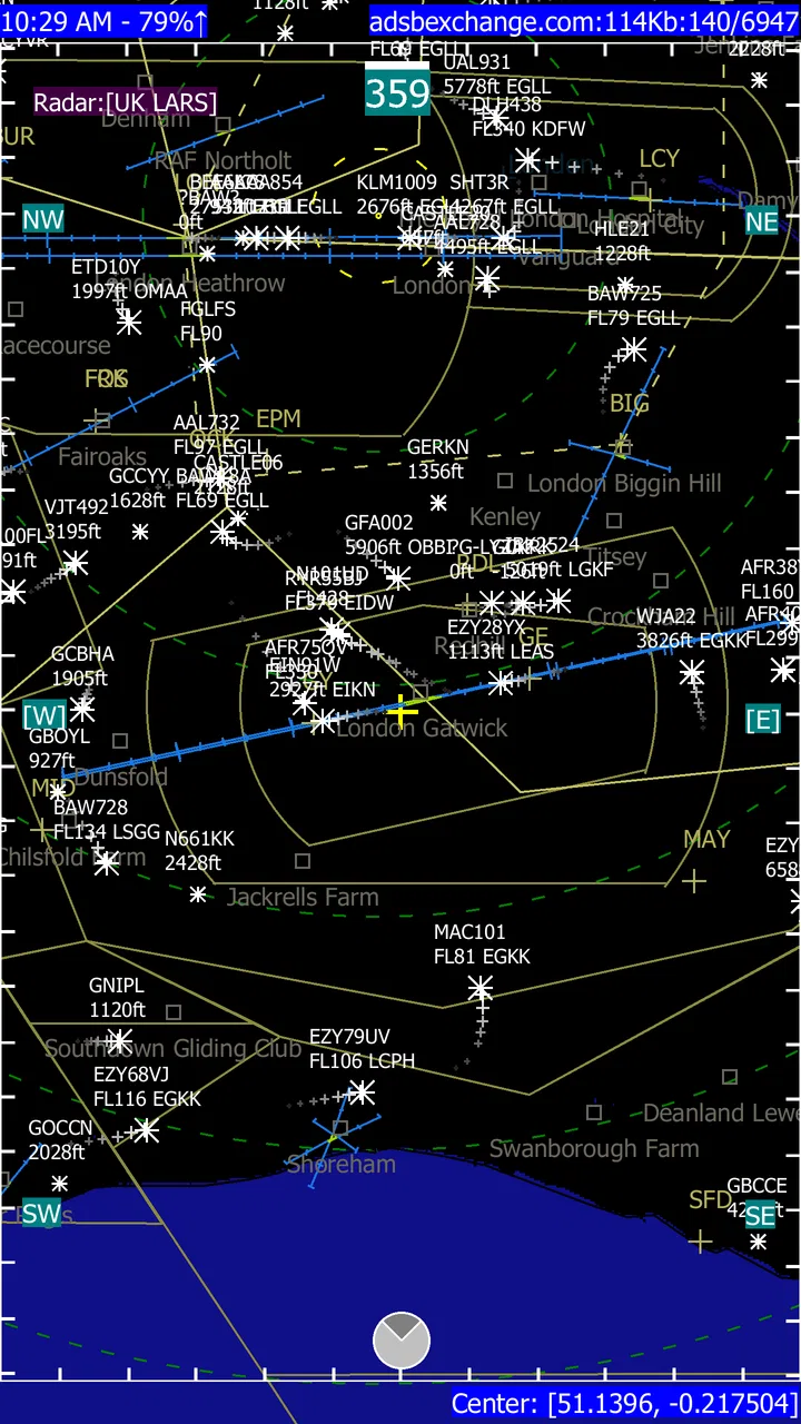
I approached ADSB Flight Tracker Lite as a practical travel companion rather than a toy radar display. Its main appeal is easy to understand: it turns aircraft tracking into something you can watch on a realistic-looking radar screen, with a simple three-dimensional presentation, while using ADS-B flight information in real time. After spending time with it, my view is that it works best for curious travelers, aviation fans, and people who want a quick visual explanation of what is flying nearby. It is less convincing as a complete trip-planning replacement for a full flight-information service.
The app sits in the Travel & Local category and is developed by CodingRealLife. It is free to install, which makes experimenting with it straightforward, although optional in-app purchases range from $0.99 to $26.99 per item. That combination matters: you can decide whether the basic experience is useful before spending anything, but you should treat the paid options as extras rather than assuming that every part of a premium flight service is included from the start.
What it feels like to use the radar
The central experience is visual. Instead of presenting nearby aircraft as a dense list first, the app puts the radar idea front and center. Planes appear in relation to your position and surroundings, giving you a better sense of direction than a simple departure board. I found that especially useful when I wanted to answer a quick question such as, “What is that aircraft overhead?” or “Why are several planes following this route?”
You May Also Like

 Blood Strike: 2.5 Anniversary
Blood Strike’s Loadouts Turn Every Drop Into a Tactical Gamble
A close look at Blood Strike’s custom loadouts: how fast access to signature weapons reshapes its battle royale rhythm, rewards preparation, and narrows the gap between fights.

 Pandora - Music & Podcasts
Pandora’s Music Is Easy to Start, but Harder to Recover
Pandora’s strength is its low-effort path from a seed to a station. Its weak spot is how much confidence it asks you to place in connection, setup, and quiet recovery.

 8 Ball Pool
 Is Built on Rivalries, Rematches, and Routine
A close look at the rivalries, rematches, shared routines, and unanswered safety questions that turn a quick pool match into a persistent mobile community.

 Samsung Music
’s Quiet Strength Is Playing What You Already Own
Its reach comes less from spectacle than from dependable access to a personal library. That simplicity is both the app’s strongest retention engine and its ceiling.

 AccuWeather: Weather Radar
AccuWeather Review: A Quick, Clear Forecast for Everyday Decisions
For everyday plans, the best forecast is the one you can understand quickly. AccuWeather makes rain timing, radar, and local conditions easy to act on, with a few trade-offs.

 Hill Climb Racing
Why Hill Climb Racing Still Turns Crashes Into One More Run
A tiny car, a bumpy hill and one more upgrade: Hill Climb Racing keeps resurfacing because its simple chaos makes every near-miss feel personal.
More From Our News Desk
View All News


The simple 3D treatment adds depth without turning the interface into a complicated simulator. You do not need to understand aviation terminology to begin exploring. The screen communicates movement and proximity in a way that feels more intuitive than scanning rows of flight numbers. For a first-time user, that visual approach is the strongest reason to try it.
There is also a pleasant difference between checking a static map and watching a live radar-style display. A map tells you where aircraft are; the radar view encourages you to observe patterns. You can notice streams of traffic approaching an airport, aircraft crossing your area, or a plane that seems to be taking a route different from the others. Those observations are not necessarily enough to identify every operational detail, but they make the app more engaging than a conventional timetable.
My advice is to open it with a specific question in mind. Start by checking the sky above your neighborhood, then compare what you see with the airport you use most often. This prevents the experience from becoming aimless map browsing and helps you understand whether the display gives you information you actually value.
Where the app is genuinely useful
A realistic everyday scenario is waiting outside an airport to collect someone. Rather than repeatedly asking whether the flight has landed, I would use the radar view to follow the aircraft’s approach and get a visual sense of its progress. It should not replace the airline’s official arrival information for timing a pickup, but it can make the waiting period more informative and help explain why an aircraft appears to be circling or taking a less direct approach.
It is also useful for families. Children often understand a moving aircraft on a screen faster than a schedule full of abbreviations. I can imagine opening the app while watching planes from a park, using the radar to connect what is visible overhead with what is happening on the display. That is a more meaningful use than simply leaving the app open as decoration.
Aviation enthusiasts may enjoy it as a lightweight observation tool. The radar perspective makes it easy to follow traffic around a familiar airport or compare the directions aircraft take at different times. The important word is “lightweight”: I would not choose it as my only tool for detailed aircraft research, but it is a convenient way to begin investigating what is happening in the sky.
Travelers can use it before a journey as a visual aid, particularly when they want to understand the traffic around an unfamiliar airport. It may help someone become more comfortable with the idea that an aircraft’s route is not always a straight line from origin to destination. Still, for gate changes, baggage information, boarding times, or airline messages, the carrier’s own app remains the better choice.
Three details that improve the experience
First, I would use the radar as a context tool rather than a replacement for official travel information. When an app shows movement in real time, it is tempting to treat every position as a promise about arrival time. That is a mistake. A live aircraft view can help you understand movement, but airport operations and airline schedules are the authority when a decision has consequences.
Second, the three-dimensional view is most useful when you keep your attention on relative position. Looking only for a plane’s label can make the screen feel busy, while observing whether traffic is converging, spreading out, or passing overhead gives the display a clearer purpose. In my experience, the visual layer is valuable because it turns abstract tracking into spatial awareness.
Third, I would use it in short sessions and save the deeper exploration for locations that interest you. Watching the same empty area for too long can make the app feel limited, even though the radar concept is working as intended. Switching between a home area, a busy airport, and a place you plan to visit gives the app more variety and reveals where its strengths are most noticeable.
These habits also clarify the trade-off behind the product. The more you want a quick, visual answer, the more appealing it becomes. The more you want a complete operational record, the more likely you are to prefer a specialized flight-information platform with broader search and notification tools.
The most important limitation
The app’s focused design is both its strength and its weakness. A radar screen is immediately understandable, but it does not automatically answer every question a traveler has. Someone checking a flight for a business trip may care more about terminal details, delays, gate changes, baggage belts, or airline communication than about seeing the aircraft move across a map.
I also would not rely on the display alone when accuracy is critical. Real-time tracking can be affected by the nature of aircraft broadcasts, coverage, timing, and the way information is presented. The app is best treated as an informative live view, not as a guarantee that every aircraft in the sky will appear or that every position should be interpreted as exact operational guidance.
The free entry point is welcome, but the presence of optional purchases means users should pay attention before buying anything. I would first spend time with the no-cost experience, decide whether the radar view fits my habits, and only then consider an upgrade. If your interest is occasional curiosity, paying for extras may not improve your day-to-day use enough to justify the expense.
Another point is the age of the minimum operating requirement. The app supports devices running Android 9 or later, so anyone using an older phone should check compatibility before planning around it. On supported hardware, the simple presentation should be approachable, but the quality of the experience will still depend on how comfortable you are reading a moving radar-style interface.
How it compares with familiar alternatives
Compared with an airline app, ADSB Flight Tracker Lite is more interesting for observing the wider sky and less useful for managing one specific reservation. An airline app knows the passenger-facing details that matter to a journey. This app offers a broader visual perspective, which is better when you want to understand surrounding traffic rather than receive a boarding instruction.
Compared with a traditional airport departures board, it is more dynamic and spatial. A board is faster when you already know the flight number and simply need a status. The radar view is better when you do not know which aircraft you are seeing or when you want to understand how traffic is moving around an airport.
Compared with a dedicated aviation enthusiast platform, it feels more approachable but potentially less suitable for intensive research. A specialist service is usually the better choice for users who need extensive aircraft history, detailed filtering, deep registration research, or a large collection of operational tools. This app makes more sense for someone who values immediate visual feedback and does not want to learn a complicated aviation interface.
That distinction is important because the app should not be judged as though it were trying to do everything. Its clearest identity is a live radar-style viewer with a simple 3D perspective. If that is the feature you want, its focused approach is a benefit. If you expect a full travel command center, the same focus will feel restrictive.
Who should install it
I would recommend it to people who look up when they hear an engine overhead, travelers who enjoy understanding airport traffic, families watching aircraft together, and aviation beginners who want an approachable starting point. It is also a good fit for anyone who prefers learning through a map-like visual display instead of reading a long list of flight records.
The app has reached over 50 thousand installs and carries an average rating of 3.8 from roughly 286 ratings, with about 25 written reviews. Those figures suggest a modest but real user base rather than a universally praised service. I would read that as a reason to keep expectations measured: it is worth trying for its specific radar concept, but not something I would install assuming it will replace every other travel tool.
The Everyone content rating makes it suitable for general audiences, and the free starting price lowers the risk of trying it. Still, “free” should not be confused with “complete for every purpose.” I would install it if I wanted a visual aircraft tracker, then judge it on that job rather than on features designed for airline passengers or professional dispatch work.
I would skip it if my main goal were booking flights, receiving dependable gate alerts, managing loyalty accounts, or checking a detailed itinerary. I would also look elsewhere if I needed advanced aviation analysis or wanted to treat the app as a formal source for operational decisions. In those situations, an airline, airport, or specialist tracking service is a better match.
Version, access, and long-term value
The current version is 14.3.1, and the app was released on February 5, 2019. Those details give the product some history, but the more important question for me is whether its focused design still fits the way I want to use a flight tracker. If I only need occasional visual checking, the simple concept remains appealing. If I expect constant travel management, I would probably combine it with another service rather than depend on it alone.
The optional purchase range, from $0.99 to $26.99 per item, makes it especially sensible to test the basic version first. I would not pay simply because I enjoy the radar animation. I would pay only if an available extra solves a recurring problem in my own workflow. That is a useful rule for this app because its core attraction is easy to understand before spending anything.
One practical routine would be to use the free version during a week of normal travel or local plane watching. Check it near a busy airport, use it during one pickup, and try it when you notice aircraft overhead. After those sessions, you will know whether the radar view provides information you genuinely use or whether the novelty fades quickly.
My final assessment
ADSB Flight Tracker Lite succeeds because it makes aircraft movement feel tangible. The realistic-looking radar screen and simple 3D presentation give ordinary users a quick way to explore the sky without starting with a technical aviation database. I especially like it for casual observation, airport-area awareness, and explaining flight paths to someone who would find a list of codes confusing.
Its weakness is equally clear: the visual tracker is not the same thing as a complete travel assistant. It cannot be my first choice for passenger alerts, itinerary management, or high-stakes timing. The optional purchases also deserve a cautious approach, since the best value depends on whether the app becomes part of your regular routine.
My recommendation is therefore specific rather than universal. Install it if you want a simple, visual way to watch nearby aircraft in real time. Use it alongside official airline or airport tools when traveling, and treat the radar as context rather than a promise. For aviation curiosity and everyday plane watching, it is an enjoyable free starting point; for detailed travel management, I would choose a more specialized alternative.
FAQs for ADSB Flight Tracker Lite
01What is ADSB Flight Tracker Lite used for?
ADSB Flight Tracker Lite is designed for monitoring aircraft that broadcast ADS-B position information. It can show nearby flights on a map and provide details such as an aircraft’s identification, altitude, speed, heading, and route when that information is available. It is mainly useful for aviation enthusiasts, plane spotters, travelers, and anyone who wants a convenient way to explore local air traffic.
02Does ADSB Flight Tracker Lite require an internet connection or special hardware?
The app’s exact requirements may vary by device and version, but flight-tracking applications generally need a data connection to download map information, aircraft data, or online flight details. Some ADS-B tracker setups may also work with a compatible local receiver, depending on the app’s supported sources. Before downloading, check the store listing and in-app instructions to confirm whether your preferred tracking method is supported.
03How accurate and complete is the aircraft information shown in the app?
The information displayed by ADSB Flight Tracker Lite depends on the aircraft’s ADS-B transmission, receiver coverage, network availability, and the quality of available databases. Not every aircraft broadcasts the same details, and some military, private, or unregistered aircraft may be missing or shown anonymously. Position updates can also be delayed or unavailable in areas with weak coverage, so the app should not be treated as an official real-time aviation service.
04Can I use ADSB Flight Tracker Lite to follow a specific flight or identify a plane overhead?
You can typically use an ADS-B tracker to inspect aircraft visible in your area, select an aircraft on the map, and review available data such as its callsign, registration, altitude, direction, and route. Whether a particular flight can be followed depends on its transponder information and the coverage around you. For the best results, enable location access if requested and use the app outdoors with a stable internet connection.
05Is ADSB Flight Tracker Lite free, and are there any limitations to expect?
The Lite version is generally intended to provide core aircraft-tracking features without the full set of tools offered by a premium edition. Depending on the release, limitations may include advertising, fewer map or filtering options, restricted historical data, or limited access to advanced flight details. Review the current Google Play or App Store listing for pricing, permissions, supported devices, and any in-app purchases before installing.
Pros
- Shows nearby aircraft with live position data on a clear map.
- Supports multiple map styles for easier viewing in different situations.
- Aircraft details include callsign
- altitude
- speed
- and flight direction.
- Lightweight design works well on older Android and iOS devices.
- Useful for plane spotting near airports and tracking flights overhead.
Cons
- Coverage depends heavily on local ADS-B receiver availability.
- Some aircraft may appear late
- disappear
- or show incomplete details.
- Free Lite version may include advertising during regular use.
- Map tracking can consume noticeable battery during extended sessions.
- It may be less useful in remote areas with limited data coverage.

ADSB Flight Tracker Lite
Gallery